By Skyhawk to Florida – Day 6 – Texarkana to Florida

After a long – and sometimes frustrating – day, we’ve made it to Florida.

The weather this morning in Texarkana was beautiful, and the forecast was for the rain which was over north Florida and Georgia to have moved offshore by the time we arrived late in the day. So, with our fingers crossed, we took off from KTXK bright and early.
1238-AR-off-at-KTXS

This is the Red River in Arkansas – the cut-off oxbow bend is now called “Cypress City Lake”.
1241-AR-RedRiver-GarlandCity

I’m not sure what’s going on here. Looks like static electricity on a grand scale…1244-LA-trails

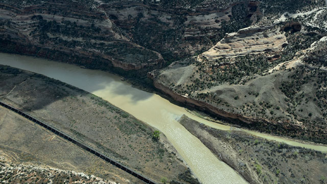
After an hour or so, we crossed the Mississippi – unlike my first crossing last week, the River was in full Big Muddy mode, complete with towboats. 1256-Mississippi

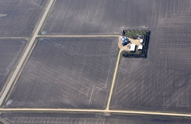
This is a tributary of the Mississippi, with farms on each bank. 1261-MS-riverfarms

I’d seen a post on the AOPA Members facebook group from the FBO at Monroe County, Alabama (KMVC), inviting people flying to Sun’n’Fun to stop in for a free buffet meal. As it turned out, KMVC was almost exactly half way between Texarkana and Clearwater, so it made a perfect stop for fuel and food. About three hours after taking off, we were on final for runway 21, KMVC.
1272-AL-KMVC

Everyone at Monroe County was as friendly as can be – the guy on the line even pumped our fuel at the self-service fuel pump. We fueled next to another airplane (a Cherokee) headed to Sun’n’Fun, then we all went into the FBO for food.1278-AL-KMVC

It was still a bit early for lunch, so they had a breakfast buffet – sausages, corn bread, grits (of course), sausage-and-egg-biscuits, coffee and other drinks, even popcorn… 1279-AL-KMVC-buffet

We filled up, then sat around talking flying while we watched the weather on our tablets or smartphones – the storms moving in from the Gulf of Mexico hadn’t moved on as predicted. In fact, they seemed to be getting worse. We waited, and watched, until it looked like there was a route along the back side, if we headed more directly south and then east. The problem is that most of the Gulf coast around there, and many miles inland, are all restricted areas and military operations areas (MOA’s). We found that we could take a corridor from KMVC to Logan (1A4), Tri County (1J0), and Mariana (KMAI), then south to Talahassee (KTLH) which avoids the various airspaces. We decided to go ahead for an hour, which would take us to KMAI, and see how things looked. If the weather wasn’t good ahead, we’d land there. If not, we’d go on to Talahassee and see how it was there, and so on.

As it turned out, we started to get light rain around Talahassee, but the visibility was still good, so we decided to press onward to Perry-Foley (40J). About ten miles from 40J the ceiling began to drop and the rain strengthened. We decided to land and wait it out – along with about eight other airplanes, as it turned out. 1285-FL-PerryFoley-40J

Perry-Foley is another very friendly FBO, with a nice airport dog and a good facility for just sitting around in. So we did, for several hours. I read some magazines, petted the dog, talked flying, checked the weather, autographed the Sun’n’Fun poster on the wall… Finally, a little after 5:00 the weather broke and we got back in the air.

The route to Clearwater runs along the Gulf Coast. The weather wasn’t bad as we went along, and you could see clearing to the west.
1303-FL-coastline

To the east, most of the land is pine scrub or mud flats with interesting channels. 1300-FL-mudflats

As we neared Clearwater, it turned out that the storms had moved on – but they’d left behind a low deck of broken clouds at about 800-1,200 feet. We threaded our way through the clouds and the busy workspace (talking to Tampa Approach along the way), until we arrived at KCLW – and for a miracle, the deck broke enough to make our landing uneventful at last.
1316-FL-KCLW

For an extra eight dollars a night, they offered an open-sided hangar for 493, which I decided was worth it. The Cessna’s done a fine job, and earned a week in the shade.1318-FL-KCLW-493

We’re off to Sun’n’Fun tomorrow morning, and all week. If everything works well with the weather (and when does that happen?) we will be back in the air a week from today. As ever, watch this space…

<- Back to Day 5: Santa Fe to Texarkana | Ahead to Sun’n Fun Report ->

By Skyhawk to Florida – Day 5 – Santa Fe to Texarkana

Today’s weather in Santa Fe was picture perfect – clear blue cloudless skies – albeit with a very strong north wind. We dropped off the rental car and were in the air by 9:00 Mountain Time. We climbed to about 8,100 feet to clear the hills southeast of Santa Fe – once you’ve made it over those ridges, it’s downhill all the way to Florida.
1184-NM-leavingKSAF

This is a map of our route for the day, courtesy of CloudAhoy, which I had running on the iPad to log the trip. With slight jogs to fit in waypoints at roughly 65-100 mile intervals, we headed basically east southeast for the entire day, crossing from New Mexico into the Texas panhandle, then following the Texas-Oklahoma border most of the day, dropping back into Texas for a while, then finishing up at Texarkana, Arkansas.
Day5route

Once you leave the hills around Santa Fe, Eastern New Mexico is essentially flat, brown and mostly uninhabited. Roads ramble here and there, for all appearances purposeless. Surely there was a reason for these tracks to follow the paths they did – but what? Something to ponder as the miles slip by under your wings. 1185-NM-roads

At the perhaps ironically named town of Happy, Texas, there is a huge feedlot. A billion Big Macs on the hoof – I’d guess it’s not all that happy for them.1196-TX-feedlot-HappyTX

Once into Texas the land becomes much greener and more intensively farmed. At this point, some ranch roads approach and cross the wonderfully named “Prarie Dog Town Branch of the Red River”.
1201-TX-Silverton-PrarieDogTownBranch

As we progressed east, the winds got stronger – much stronger. Every airport we passed was reporting in the mid-to-high 20knot range, with gusts into the mid-to-high 30’s. We had originally planned to stop off for fuel at Memphis (Texas, not the famous one), but it turned out that they don’t have it. So, we switched to landing at Childress, Texas (KCDS), about 3 hours after leaving Santa Fe. The KCDS ASOS automated weather reported 330 degrees at 24, gusting 32, but they have a runway 36 so I decided to go for it. My landing wasn’t bad, but taxiing with a 30+ knot wind can be really interesting. The Cessna really didn’t want to turn at some points as we taxied to the fuel pump. Fortunately, it was a credit card self-serve pump, since the FBO was closed. 1208-TX-Childress-KCDS

There were tumbleweeds tumbling across the taxiways – I stopped to let this one go by…1214-TX-KCDS-tumbleweed

We had wanted to grab lunch at Childress, but it was not to be. The airport has a courtesy car (like Hamilton, it’s a former police car), but with the FBO closed there was no one to give us the keys. There was no way to get into town, about two miles away, other than walking. Not that two miles is such a big deal, but we didn’t want to waste more than an hour getting there and back, plus the delay in eating. So, we taxied back to Runway 36 and took off – with a 30+ knot wind down the runway, old 46493 felt like a STOL 172. We were halfway to takeoff speed before starting the roll!

We continued to follow the Red River, Oklahoma on one side, Texas on the other. From this picture, it’s clear why it’s the “Red” river…
1225-OK-TX-RedRiver

Having passed Memphis-not-in-Tennessee, we continued on to pass Chattanooga – also not in Tennessee. This one is in Oklahoma.
1226-OK-Chattanooga

That sort of thing isn’t really unusual. As land played out in the East, settlers would move west and establish new communities named after the ones they had left. You can find strings of similar names across the country – think of Ithaca, New York, and Ithaca, Michigan (or Lansing, in both states), Rochester, New York and Minnesota, and so on.

Clouds began to gather as we left Childress. The further east we went, the lower the clouds, until we were down at about 3,200 feet, here at Texoma Lake.
1228-OK-LakeTexoma

At three hours, fifteen minutes, after leaving Childress, we were on a right base for Runway 22 at Texarkana, Arkansas (KTXK).
1233-AR-KTXK-base22

The folks at the TACAir FBO couldn’t have been nicer. They arranged to fuel and tie 46493 down for the night, then arranged for a hotel room and rental car for us, both at a discounted rate.
1237-AR-KTXK-493

As it turned out, we landed just in time. As we drove up to the hotel, only four miles from the airport, it started to rain and a thunderhead appeared, with active lightning for a few minutes.

If everything works as planned (and when does that happen?) tomorrow afternoon we’ll be in Clearwater, Florida (KCLW). Texarkana is almost exactly halfway from Santa Fe to Clearwater, so if the weather continues to blow off to the east we should be able to make it in six or seven hours. We’ll see – as ever, watch this space!

<- Back to Day 4: Mack to Santa Fe  | Ahead to Day 6 : Texarkana to Florida->

By Skyhawk to Florida – Day 4 – On the way to Sun’n Fun!

The weather in western Colorado (that’s western Colorado as in “it’s always sunny in Fruita”) has been utterly wretched for the last three days. We’ve had snow, and rain, and this morning when I woke up you couldn’t see across the street for the fog. It took until noon before the clouds lifted enough that we could get out of Mack Mesa.

My plan for the first day of the second leg of the trip was to head south from Mack Mesa to Gunnison, climbing to about 12,500 feet to cross at Marshall Pass. Then, descend to Pueblo, Colorado for breakfast and fuel, and on to Liberal, Kansas for a half day at the Air Museum. But, this is one of my trips west, so…

Greetings from Santa Fe, New Mexico.

As I’d said, it took until noon for the clouds to lift, but they didn’t lift anywhere near enough to allow crossing the Rockies at any of the available passes. The clouds were at or below mountain level both north and south of the valley that Mack’s in, and the highest ceilings along the original route were well below the passes. So, we replanned the trip to head west to Utah, then turn left and follow the valleys down to Santa Fe. As it turns out, it’s entirely possible to do that route at no higher than 7,800 feet. Once the ceilings along the way got higher than that, we were off.
1111-CO-off-at-Mack

The sun broke out as we neared the Utah state line, following the Colorado River as it wound its way.
1114-CO-ColoradoRiver

Note the railroad train, paralleling the road, paralleling the river… not too many flat spots to put a transportation system in those narrow canyons…
1118-CO-ColoradoRiver-train

The valley opens up as you enter Utah, and the ceiling lifted and became much more broken, too.
1128-CO-ColoradoRiver

This is Fisher’s Towers, a well-known photography spot not far from Moab.1132-UT-FisherTowers

Moab is just over the ridge, through the pass ahead. We dodged the clouds, and went past Castleton Tower close on the right. Very impressive from that point of view…1136-UT-CastletonTower

From just south of Moab, we turned southeasterly toward Dove Creek VOR (DVC), which sits in a corner of a farmer’s field.
1138-CO-DVC-VOR

From Dove Creek VOR, the route crosses Cortez (CEZ) and Rattlesnake (RSK) VORs. Rattlesnake is east of Farmington Four Corners Regional Aiport (KFMN), and was our first waypoint in New Mexico. By this time we were indicating between 125 and 135 knots groundspeed – after fighting headwinds all the way out it was so great to have a significant tailwind for a change.

By the time we got to Cortez we were able to climb up to 8,300 feet, which put us comfortably above anything nearby for the rest of the trip. The weather report (METAR) at Santa Fe had changed to a 4,100 foot ceiling, which meant not only that they were full VFR, but the clouds were over 10,000 feet (KSAF is at 6,400 feet). We could be sure that not only did we have lots of air below us, we were also comfortably clear of clouds, too. I should note that this was one of those times I was glad I had the Garmin GDL-39 ADS-B receiver – getting real-time weather uploaded as long as you’re in range of an ADS-B ground station is a real plus.

There were a lot of oil and gas wells in New Mexico. This one was out in the middle of nowhere, with nothing at all for miles but the rocker pump and storage tanks. Presumably someone must come along from time to time and empty the tanks – it must be quite a drive to do so.
1153-NM-oilpump

Santa Fe is effectively in the next valley over from the one we’d been following – with the Sandia Mountains in the way, peaks at 9,000 feet and up. You have to continue southeast until you’re nearly due west of Santa Fe before you can turn left and aim for the airport (PEDRA interection, if you’re following along on a sectional chart). We did so, and as soon as we did we started hearing Santa Fe Tower. We called in about 25 miles west of the field, and were told to expect runway 28, as the winds were varying between 270 and 290 degrees at 17 knots, gusting 24 knots. Before long we cleared the last ridge, and Santa Fe was straight ahead.
1157-NM-KSAF

We were cleared to land while we were on downwind, number two behind another Skyhawk. They weren’t kidding about the gusts – about 200 feet up, 493 sort of bounced upward and rightward. That got my attention, believe me. Nevertheless, I think my landing was quite creditable, if I do say so myself. At least, Jerry didn’t scream and grab the yoke or anything… and we were down and parked at Landmark.
1161-NM-KSAF-493

Tomorrow, we’re heading east – the plan is to get to Texarkana at least, but I’m not really sure how far we’ll get.  The weather controls, as always…

<- Back to Day 3-Cheyenne to Mack   |   Ahead to Day 5 – Santa Fe to Texarkana ->

Aerostar Trip to the Dominican Republic – KFXE – MDST

130 to 310!!  That’s the true airspeeds of the slowest and fastest planes in our group of 12 flying out to the Dominican Republic today.

C172ROur leader Jim Parker has been flying the islands for decades and has been to over 110 airports throughout the Caribbean.  He flies an really interesting airplane, a Cessna 172RG.  Yep – it’s basically a 180hp Skyhawk –  called a Cutlass,  a lot like the club’s Skyhawks except the gear retracts and with that added complexity comes about 20 knots.  This one flies at 130knots.

With a strong bladder and/or a fuel stop, the 670nm from Ft. Lauderdale is well within the reach of a Skyhawk.  One of our group flew down from Montana in their 1963 Bonanza. Bonanzas of that vintage are 130knot machines.  On the other end if the spectrum was a Cheyenne II twin turboprop and three single-engine turboprops, the fastest being an Epic homebuilt cruising at 310knots at FL270!  Rounding out this eclectic fleet were a couple Piper Saratogas, an Aztec, a Navajo Chieftain, a B55 Beach Baron and us.

After an early morning briefing — mostly learning each other’s names, where the fuel pit is at Santiago and how to deal with air traffic control in the islands, off we went.  Well, not really.  The turboprops and we kind of hung around since the goal was to meet in Santiago between 2 and 3pm.  Some of our group left from different Florida airports, but everyone was in the air by 10:45 am or so.

Our ride down was actually quite easy.  We filed for 19,000 ft where we had the best winds – actually, not much wind at all.  Down low, there was a 10-20 headwind, at FL 190 and above, the tailwind was in the 5-10knot range.  The route took us over most of the Bahama Island chain.  It was a beautiful day with puffy clouds over many of the islands.

The world does look different from FL190 than down low.

Over the edge of Long Island, there’s a large salt flat.Salt Flats


And farther down in the Bahamas we crossed the Acklin Islands.  We were actually never very far from land.  In the distance to the southwest, Cuba dominated the horizon.  That’s the east end of Cuba on the moving map.Acklins

GNS530


Flying in the Dominican Republic itself is a bit different.  First, about 40 miles northwest of the ALBBE intersection, Miami Center announces – “Radar service terminated – contact Port-o-Prince Center on 124.50.”  Yes, we were in Haiti’s airspace and Haiti doesn’t have civilian radar.  So, it’s back to non-radar reporting points.  Something all instrument students learn, but rarely get to use in most of the lower 48.  And unlike when I learned instruments, you always know where you are and with a push of a button, you can estimate with great accuracy the time to the next mandatory reporting point.  Pretty straight forward – except for the accents.  All the communication is supposed to take place in English and most of it is.  But with a mix of Haitian, American, Bahamian, and Latin American pilots all in the same airspace, communication became “interesting”.

We were IFR trying to get down in a non-radar environment.  Making myself understood took about 10 miles and the Haiti controller had to coordinate with the Santiago approach controller — that’s a different country.  In all, it took about 50 miles to get us a decent clearance.

By this time, we were with Santiago Approach Control which I think is near the coast in Puerto Plata.  They have radar, but it’s very spotty.  So even though they can “see” you occasionally,  you are never in “radar contact”, so everything is done in reference to DME from the Santiago VOR-DME.  In the world of GPS, we don’t hear DME (distance measuring equipment) all that often anymore.  It happens that the VOR-DME is located right at the field, so the GPS distance is fine.  Our Aerostar happens to have a DME and it was really nice to have it.

And there were a bunch of cumulus clouds over the 4,000 ft ridge that we had to fly through, so canceling IFR wasn’t a good idea; especially with four of our group all arriving at about the same time.

In addition to the basic language differences, the syntax is difference.  The controller would say:  “N60LM, Fly to Station Romeo-India-Golf-Alpha-Romeo and say DME from Cibao.” The first time I heard him,  it took a minute to figure out what he was saying. Cibao is the name of the airport – like Hartsfield is the name of Atlanta’s airport.  Station can be a fix, like an intersection or it can mean a specific airplane; “Station 60LM” and “Romeo-India et al” is the RIGAR intersection.  So, US controllers would say: “N60LM, fly direct RIGAR (and maybe pronounce it phonetically) and say distance from the Santiago VOR” (since that was in our actual clearance).   After a couple of tries, we figured out the cadence and got a clearance to the final approach fix on the ILS.  Santiago is in a broad valley, so once past the ridge, the clouds pretty much disappeared and we received a visual approach.

Finally we were turned over to the tower controller, a female voice speaking flawless English with a slight Latin accent.  With that, we were on the ground.  Only Jet A was available via truck at all of $2.47/gallon.  We had to taxi to a fueling pit and paid $6.83/gallon cash!  Here’s Trudy stretching her legs while Juan fills the main.

MDST Refuel

We had a wonderful reception right at the FBO with various officials making speeches about how great it was to have visitors to one of the busiest airports in Latin America.  And here I thought we were still in the Caribbean!  It’s the first time I can recall being greeted by Customs and Immigration eager to stamp our passports, basically ignoring our Inbound General Declaration forms, and handing us Presidente cerveza (beer) all at the same time.

More tomorrow about where we are staying.  It’s late!

By Skyhawk to Florida – Day 3 – Cheyenne to Mack Mesa

I’ve arrived at my first long-term stop, with Jerry and Barb Friedman in Fruita, Colorado.

At the advice of the folks at the FBO, I got an early start to miss the worst of the daily winds. At 7:00AM, there was only a small crosswind on Runway 27, and after using a frightening amount of the runway (Cheyenne is at 6,200 feet altitude), we were on our way.
0671-off-KCYS

On the way out of Cheyenne, the scenery is basically flat, gently dimpled, and more or less uninhabited. This railroad cuts through the bumps and fills in the low spots – but it’s not at all clear why it’s there or where it goes…
0675-Wyo-desert-RR

As I headed southwest, climbing at the best rate 493 could muster, the land came up to meet us, and became more rugged with scattered outcrops of rock.
0690-Wyo-desert

We made it up to 11,000 feet not long before we crossed our first pass, on the Wyoming-Colorado border. We flew over a low spot at the northern end of the Bow Mountains, and entered a wide north-south valley.
0701-PassWYCO

On the other side of the pass, we flew over these dunes – I’m pretty sure they’re sand, not snow. Impressive, either way.
0711-dunes

On the other side of the valley was the highest point in the trip – the mountains east of Steamboat Springs. As you can see on the altimeter, we climbed to 12,400 feet to give the pass a little extra room (11,700 would have done it).
0727-SteamboatPass-panel
0729-SteamboatPass

From Steamboat, the route was along a wide valley, via Robert VOR (BQR), Hayden VOR (CHE) and Meeker VOR (EKR).

At Hayden, they’ve got one of those end-of-the-railroad-line jug handle turnarounds. I guess I have to stop saying I’ve only seen them on Lionel layouts, since I’ve found one on each of my trips.
0739-Hayden-RR

The route continues on southwesterly from Meeker, and we started our descent. It’s a very rugged country, north of the Colorado River Valley.
0751-valley

Descending down past 9,000 feet, we crossed the last ridge and entered the valley.
0756-lastpass

And there it was – Mack Mesa Airport (1oCO), sitting on top of its ridge.
0765-10CO

The winds at Grand Junction, about 15 miles east, seemed to favor runway 25 at Mack, but I made two approaches and it just didn’t work out. Practicing go-arounds can be a very useful technique, especially in a Skyhawk with 40 degrees of flaps (hint – if you leave the 40 degrees of flaps down, you can’t go around). So, I turned around and landed on Runway 7, no problem. They need a bigger windsock – once I was down, I could find it and sure enough, the wind was right down Runway 7. Next time…

And so, 46493 is back at its one-time home, with the Book Cliffs in the background. 0767-10CO-493

We pushed 493 into the big hangar – they’re predicting high winds tomorrow – and we plan to be off early Friday morning. Watch this space!

<- Back to Day 2 – Oshkosh to Cheyenne    | Ahead to Day 4 – Leaving for Sun’n Fun ->

By Skyhawk to Florida – Day 2 – Oshkosh to Cheyenne

It’s been a long day – eight and a half hours flying – but well worth it. I’m in Cheyenne, Wyoming, ready for tomorrow’s relatively short 200-mile hop to Mack Mesa.

I got off nice and early from Oshkosh, into clear and cloudless skies. Unfortunately, there was a fair amount of wind in those skies – a 25-35kt south wind, to be precise. It took a lot of crab to hold a more-or-less westerly course, but for most of the trip the best I saw was this:

0576-Garmin430-83kt

If you’re not familiar with the Garmin 430, the lower right-hand box is Ground Speed (GS) – 83.4 knots. My airspeed was about 105 knots, so that amounted to more than a 20 knot headwind.

I’ve got two Rivers of the Day today. The first one wasn’t very big, and seemed to have a severe problem of indecision as to what way it was supposed to be flowing. 0563-WI-river

Some time later, I crossed over the second River of the Day – the mighty Mississippi, just south of LaCrosse, Wisconsin. On the other side was Minnesota, my second state of the day.
0589-Mississippi

From this point on, the terrain was pancake-flat and increasingly dry.0614-Iowa

They seem to have a thing for right angles out in the Midwest…
0600-squarefarm

0652-SD-rightangles

With the constant wind, it only seems logical to exploit wind energy – and they do. There were wind farms  sprouting all across Minnesota.
0605-windfarm

As I flew westward, the smooth conditions when I took off  became increasingly bumpy, and the reported winds at each airport grew higher. I had the choice to stop at Spencer, Iowa KSPW (state number 3, by the way), but the winds were kind of high – 23 gusting 33 – and I had what seemed like sufficient fuel, so I decided to stretch on to the next waypoint which was reporting only 15 knot winds on the METAR. So, on to Yankton, South Dakota KYKN (state number 4).

By the time I got to Yankton, the AWOS was reporting 19 gusting 31, but straight down Runway 19. The landing was interesting – felt like I was hovering at the last bit, and taxiing to the fuel pumps I was careful to use the control inputs you learn in training, but never seem to really need much in our calmer climate. Total elapsed time, four hours 51 minutes.

Jerry sent me a “welcome to South Dakota” text message as soon as I arrived (thank you FlightAware), with the note that he didn’t think there was anyone else there. There probably are, but you can’t prove it by me. I refueled, used the restroom in the airport office, and took off again without seeing a single human being.
0615-KYKN-493

With the wind strengths, I seriously considered tying down at Yankton for the night and trying again in the morning, but in the end I decided that although Cheyenne was predicting winds in the high 20’s and gusts in the mid-30’s, they had runways oriented correctly for the winds, and it was still early – worth pushing ahead the remaining 320 miles. And so I did.

In South Dakota, the circular irrigators I’d expected began to appear. What I hadn’t seen before are the little curved fillets in the corners between fields, lined out with windbreaks of trees. That must be something new, as a lot of them seemed to be rows of seedlings. These are fairly mature, though.
0630-SD-filletfarm

0628-SD-irrigation

Once again, I saw Pac Man eating a farm – with eyes, this time!
0654-SD-PacMan

Somewhere over South Dakota or Nebraska (state 5), the winds shifted around to northwest, and my groundspeed picked up significantly. For much of the last hour, I saw ground speeds in excess of 100 knots, which was very gratifying. Minneapolis Center and Denver Center both had radars down, so I had no flight following for most of the second half of the day. After about three hours, though, I was able to call Cheyenne Approach (Wyoming – state 6), and twenty minutes later, I was on final for Runway 31 (wind 310 at 22 gusting 34).
0666-KCYS-final31

Another interesting landing, with a bit more wiggle in the wind than at Yankton, and I’d arrived at KCYS. The folks at Legacy FBO were nice enough to toss me the keys to their courtesy car, and the day was over.
0670-KCYS-493

The winds are predicted to be light, first thing tomorrow morning, so I plan to be out of here early and in Mack Mesa 10CO before 10AM. We’ll see.

<- Back to Day 1 – Ithaca to Oshkosh     |       Ahead to Day 3 – Cheyenne to Mack Mesa ->

By Skyhawk to Florida – Day 1 – Ithaca to Oshkosh

Finally, after waiting all week for the weather to clear, the weather this morning was at least MVFR in Ithaca, with ceilings getting higher as I headed west. For once, everything worked right! I filed a flight plan, took off on time, landed on time, closed the… all right, let’s not talk about that… took off again, crossed a lake, and landed again – all as I’d planned months ago. That’s got to be a first for me. Anyway, at eight-thirty this morning, the ceiling at Ithaca was 2,000 and clear under, so I hopped in 46493 and took off, heading west.
0360-AwayFinally

By Geneseo I was comfortably above 2,500 feet, and basically stayed around that altitude for the entire leg as the ceiling rose above me. There was a large headwind – 25kt or more – and it’s usually best to stay low in those circumstances. My ground speed for the first few hours was in the low 80kt range, rising into the mid-90kt range over time. In time, I passed by Niagara Falls. You could see the mist rising from miles away, and even from outside the restricted area the falls were impressive. 0381-NiagaraFalls

As I passed north of Niagara, I entered Canadian airspace, and was handed off to the St. Catherine’s controller. In case you haven’t done it before, overflying Canada is not a big deal. You just have to be on a flight plan and assigned a transponder code before you enter Canada, and then you just go. No need to deal with e-APIS or customs notifications or anything like that, as long as you don’t land in Canada.

This was my first time dealing with Canadian Air Traffic Control, and it was interesting. They must be the politest controllers I’ve ever spoken to, for one thing. For another, the terminology is just slightly “off” for ears used to decades of FAA-speak. I got used to it, but you have to listen carefully at first. The other interesting thing about Canadian ATC is that the enroute controller handed me off to the tower of every airport I passed by (or switched me to the CTAF at untowered airports), then picked me up again on the other side. That took some getting used to, as well. The last Canadian controller I talked to signed out with “good luck – at that speed it’s going to take you a long time to get to Wichita!”  “It beats walking”, I said, and he agreed.

After an hour or so, the St. Clair River and Lake Huron appeared at Fort Huron / Port Edward, and I was back in the USA.
0407-LakeHuron-PtEdward-PortHuron

My route entered the US at St. Clair (KPHN), and then it wasn’t too long before I was on the ground at Owasso Community Airport (KRNP). Owasso is a nice uncontrolled field with two turf runways and a longer asphalt runway 11/29. There’s a self-service fuel pump outside the airport office, and a small, but very friendly, cafe which serves quite tasty omelets.
0420-KRNP-493

I availed myself of all three – after four hours fifteen minutes in the air, 493 needed fuel, and after listening to all that fluid going into the tanks, I needed the airport office’s restroom desperately… enough said about that… In the interest of full disclosure, sometime between taking on fluid and getting rid of it, closing the flight plan slipped from my mind. Somebody from the airport came into the cafe and told me to call Flint Tower – oops. A good apology always works… After lunch, I took off again and headed northwest across Michigan. I suppose I should continue the “river of the day” tradition…     0424-CrotonDamLake

About 45 minutes out from Owasso, I’d climbed up to 4,500 feet so as to have a little more air under the wings as we crossed Lake Michigan. The Nordhouse Dunes stretch northward of Big Sable Point, and that’s the point where I turned westward to cross the Lake just north of the restricted zones.
0432-Lake-NordhouseDunes

Crossing Lake Michigan was another new experience for me. Once you get off shore, there’s nothing to be seen but water and sky – it’s 44 miles from Big Sable Point to the point just north of Manitowoc, and for most of that time you can’t see either shore. It’s easy to see how people get disoriented under those conditions. It was fairly clear by Eastern standards, but the horizon still wasn’t all that sharp. Finally, Manitowoc appeared out of the mist, and we’d made it across…
0437-Lake-Manitowoc

Forty miles further along, and I was on a two-mile final for runway 27, Oshkosh (KOSH).   0442-KOSH-final27

In investigating places to stay in Oshkosh, I found that the Hilton Garden Inn had a picture on their website showing airplanes parked outside. I’d called them, and sure enough they had their own private ramp for guests. How could I pass that up? When I landed I told the controller that I was going to the Hilton, and he said “taxiway Bravo, turn left on Bravo 3”, and I was there.
0443-OSH-Hilton-493

I checked in as quickly as I could, and walked the mile or so to the EAA Museum across the airport. I had an hour to spend there, and it was great.         0511-EAA

We’ll see what nature has to throw into the mix, but my plan for tomorrow is to push all the way to Cheyenne, Wyoming, and pick up a day. If that works I can get to Mack only one day late. We’ll see…

<- Back to Intro: By Skyhawk to Florida  |  Ahead to Day 2: Oshkosh to Cheyenne ->

Aerostar Trip to the Dominican Republic – KITH – KFXE

Successful flying is all about adapting to changes. And on Friday, there were plenty of changes. When we got up in the morning, the occluded front in the Virginia area wasn’t going to be much of an issue other than an area where if we had to land, there were low ceiling and visibilities.  However, the cold front with a line of thunderstorms were going to be a problem unless we left relatively early or wait it out.  When I looked at the winds aloft forecast, it appeared that we’d have around a 30 knot headwind.  Not too bad.  So after changing our initial fuel stop from St. Augustine FL to Walterboro, SC off we went.

I found that 14,000ft was clear of ice and turbulence which were both being reported.  The ride was fine, just slow.  Instead of a 30 knot headwind, it was more like 50knots.  And it didn’t make a lot of difference what altitude we picked. So…3:48 later we landed.

Screen Shot 2015-04-11 at 8.33.01 AM Screen Shot 2015-04-11 at 8.34.14 AM

After refueling (fuel is a LOT less expensive than it is in the Northeast), we headed for Florida.  As we got farther away from the front, the winds dropped off.  1:56 later and dodging a few rain showers in FL, we landed at Ft. Lauderdale Executive.  Made for a long tiring day.  For us, that was one of the “longest” flights we’ve made down the coast in the Aerostar.  On the other hand, the first trip I ever made by small-plane to Florida in 1975 took over 13 hours in N3775A, our Piper Tri-Pacer!

We head to the DR bright and early on Monday.  I hear there are some “turbine” planes coming along and that the Jet A fuel price in Santiago is quoted at $2.47!!  We’ll see!

Trip to Dominican Republic via Aerostar

In mid 2011, we did a “long” cross country to Alaska and back via our Aerostar.  This time, the trip is shorter, but with significant over water flying. My wife Trudy and I are headed to the Dominican Republic starting on April 10 and returning to Ithaca 10 days later.

This time, we are doing an escorted trip with Caribbean Flying Adventures.  http://www.caribbeanflyingadventures.com/. Jim Parker has run this website andCFA company for many years.  It’s a great source of flying information, fuel prices, and how best to deal with various bureaucracies throughout the Caribbean.  He also puts together escorted tours.  So, we’re giving it a try.

The trip from Ft Lauderdale Executive Airport (KFXE) to Santiago, DR (MDST) is aboutFXE-MDST670nm, a little under five hours in a Mooney, but only 3 hours in our Aerostar.  The direct route skirts the southern Bahamas.  For us, we can easily do this trip non-stop.  Jim helps with the paperwork, makes the hotel reservations, and is our guide.  Unlike our Alaska trip, each plane flies on its own — no group flying.  In the airplane, we pack a couple of life preservers (required) and a four-man raft — thank you Mike Hall.  For us, bathing suits, shorts, casual clothes, and suntan lotion!  As for the others going on the trip, we’ll meet them on Monday at KFXE.

First we need to get to Floriday. We head out Friday morning fromITH-FXE Route KITH to KFXE.  Right now, it looks like we’llh ave IFRFriAMFRconditions in the morning  from here down through southern Virginia.  Depending on the weather and position of the fronts in the morning, we might go a bit west of the planned route to get out of the weather sooner.  Also, there will likely be a headwind, so we’ll need to make a fuel stop, probably in KSGJ (St Augustine, Fl). That’s the plan for now.  I’m sure it will change. Watch this space for more updates on the trip.